Smart Trail Network manager
Map your trails. Run everything behind them — maintenance tracking, live conditions, interactive maps, and beautiful visitor reports.
Everything your trail organization needs — and more
TrailsIQ is a full-featured trail network management system. Whether you manage a single community trail or a complex multi-network system, TrailsIQ gives your organization the tools to communicate trail conditions, coordinate maintenance, manage expenses and inventory, and engage visitors — all from one place.
A complete toolkit for trail managers
Built on a decade of real-world trail management experience, TrailsIQ covers every workflow a modern trail organization needs.
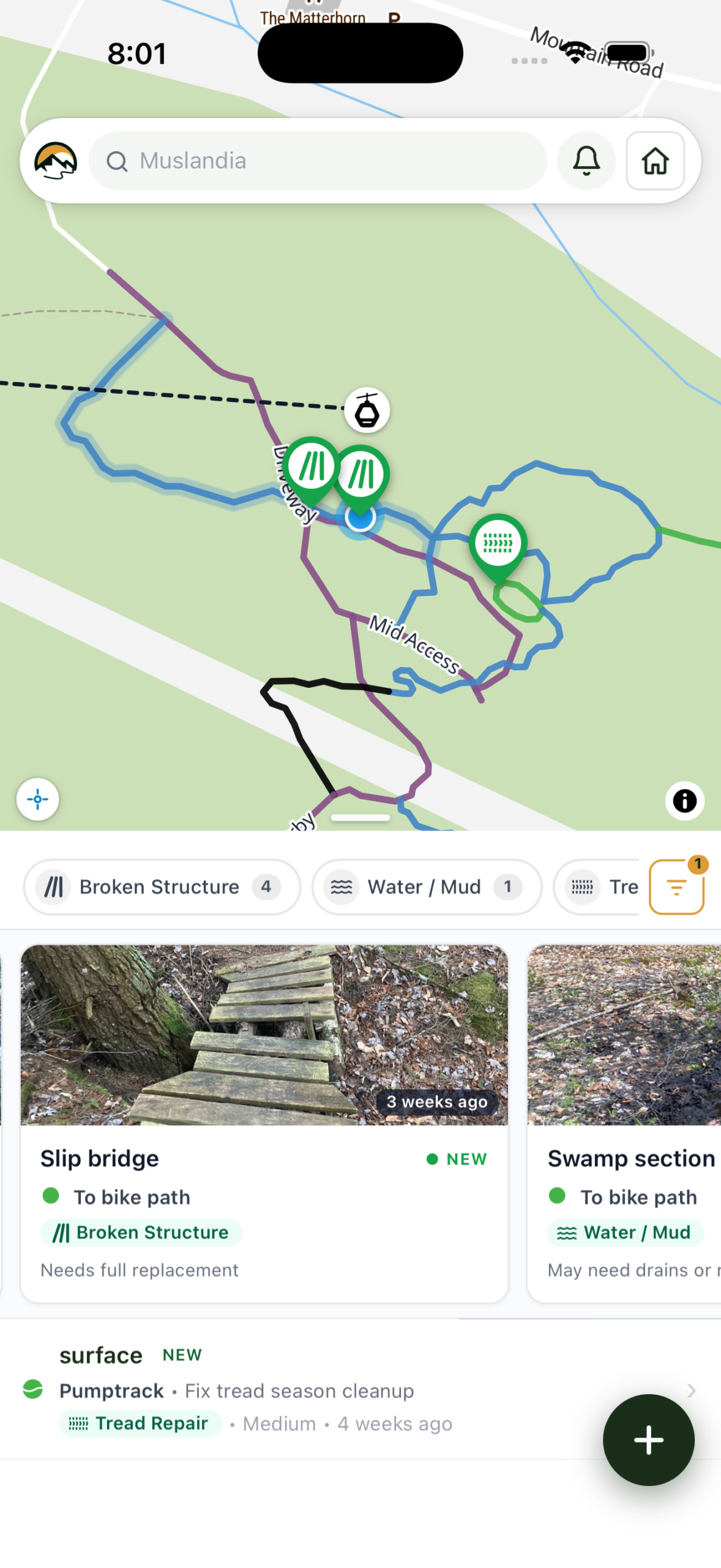
Geo-tagged Visitor Reports
Trail users submit reports with photos and GPS from the trail. Each report auto-attaches to the right trail and organization — no manual lookup.
Learn MoreField App, Works Offline
Submit trail issues and record new trails from the backcountry. Syncs automatically when you’re back in range.
Learn MoreToday’s report, in one place
Daily trail + lift status, rain/snow stats, weather, and crew updates. Reads to your team like a clipboard, ships to your guests like a press release.
Data Driven Trail Conditions
Live national weather and satellite soil-moisture data runs through a per-trail Data-driven engine that recommends Open, Caution or Closed — and explains why in plain language.
Learn MoreRecord trails with GPS
Walk, ride, or ski the route and TrailsIQ captures the line, length, and elevation in the field — no GPX exports, no clipboard juggling.
Learn MoreReal-Time Trail Alerts
Visitors get an instant push notification when a trail’s status changes or an organisation posts an important update or event. They follow the trails they care about, TrailsIQ keeps them informed.
Learn MoreAreas & Per-Trail Control
Group trails into areas. Set status at the network, area, or individual trail level — every change cascades to member trails automatically.
TRAFx Counter Integration
Upload counter data files; TrailsIQ parses them, assigns readings to trails, and generates usage reports per network.
Learn MoreTrack every lift
Cable type, capacity, vertical, last inspection — plus today’s wind holds and wait times. Lifts ride alongside trails on the map and the daily report.
Tools & Inventory Tracking
Track tools, signs, and materials by storage location. Stock deducts the moment a crew member logs an item used on a work order — no month-end count chase.
Field Expenses & Approval
Crew members file expenses from the field app with receipts and trail tags. Approvers accept the queue in one swipe and export a reimbursement PDF when the books are due.
Drag & Drop Site Builder
Build your public site directly in TrailsIQ — heroes, feature grids, a live conditions map, contact form. Blocks pull from your live trail data, so the site stays in sync automatically.
Up and running in minutes
No dev agency. No long onboarding. Just install, import and publish. Getting TrailsIQ live on your site takes less time than your morning coffee.
Sign up
Create your TrailsIQ account in under a minute. No install, no servers, no plugin — your trail database is live from the moment you register.
Import your trails
Drag and drop GPX files or live record trails right on the map. Set difficulty, primary use, allowed user types, and any custom attributes from a single screen.
Organize your network
Group trails into networks, catalog the bridges and signs that hold them up, and drop pins on the parking lots, kiosks, and trailheads visitors actually need to find.
Take it to the field
Log issues, record GPS tracks, catalog infrastructure, online or offline. Trail visitors flag problems through the TrailsIQ Report app and submissions route straight to your phone for triage.
Close the loop between visitors and your crew
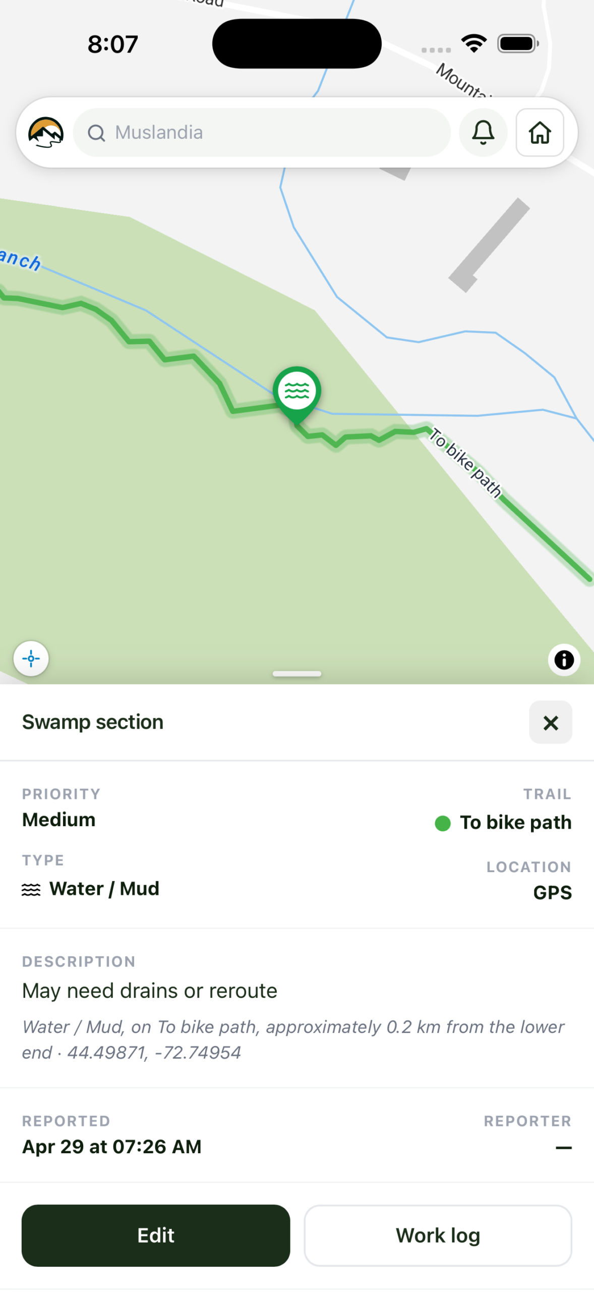
TrailsIQ turns visitor reports into an organized maintenance workflow. Every issue lands on your dashboard with a precise GPS pin, photos, and the right crew already pinged — from the moment a trail user taps “report” to the day you close the ticket out.
Visitor-submitted reports
Visitors flag a blowdown, broken sign, or muddy section in seconds — through the TrailsIQ Report app, no account or sign-up. GPS, photos, and the trail they’re on attach automatically.
Routed to the right organization
Reports land with the trail organization that maintains the trail the visitor selected, pinned to the exact spot on your maintenance map. Your crew taps the pin for one-tap directions — no “near the third bridge” guesswork.
Instant crew notifications
The TrailsIQ Field App alerts your team the moment a report comes in. Roles control who gets the push; everyone else sees it queued in the dashboard.
Tracked from new to finished
Status moves from open → in progress → finished, with an optional pending-review step for manager sign-off. Time logs, photos, and resolution notes build a complete maintenance history you can audit or export.
Your trail crew’s whole workflow — now in their pocket.
Built for crews who work where the Wi-Fi doesn’t. Records new trails by walking them. Logs blowdowns, erosion and drainage issues with photos and GPS in seconds. Works fully offline; syncs when you’re back in range. Every report lands tagged and ready to action — no manual entry, no “where was that again?”, no paper.
- Works fully offlineTrails, markers and reports cache to the device on first open. Submit reports from the middle of nowhere — they queue on the phone and push automatically the moment signal returns. Pending reports even show a sync indicator so crew know their work is safe.
- Everything is GPS-taggedNew trails get recorded as you walk them. Issue reports auto-capture the device’s current location. No more “it was somewhere past the second switchback” — every record lands on the map with a precise position.
- Photos that stay with the reportSnap one, snap five. They upload compressed, attach to the right maintenance item automatically, and become the headline visual on the admin dashboard.
- Built for thumbs in glovesChunky tap targets, high-contrast status pills, clear photos-first layout. Designed for sunlight on a phone screen after you’ve just hiked five miles in, not for a mouse at a desk.
Not a screenshot. Interact with it.
Report an issue
Add details
Trusted by trail organizations worldwide
TrailsIQ transformed how we communicate trail conditions to our members. Setup took one afternoon.
Our volunteers love the report app. Issues get logged in the field and we fix them faster than ever — and we replaced three spreadsheets in the process.
Finally a trail map solution that actually works offline. A game-changer for remote networks.
STOP RUNNING YOUR TRAILS OUT OF A SPREADSHEET
Give your trail organization the tools to communicate better, work smarter, and prove their impact.
No credit card required · Free forever plan available