Maps
Map overlays — streams, wetlands, public land and property lines
The overlays that come from public agencies rather than from your own data: what each one answers, why property lines appear in some places and not others, and why a parcel boundary is not a survey.
Streams, wetlands, public land, weather radar and property lines — what each one is for, where it comes from, and where it stops.
Turning them on
Field app → Layers → Compliance overlays.
On the dashboard they are in the layers button on the map itself — the same button that switches the base map, under Environment for streams, wetlands, radar and public lands, and under Property lines for parcels. Every dashboard map has it, so the overlays are wherever you are: the trail you are reading, the planned line you are drawing, the project you are pricing. They used to be a row of chips above one planner page's map and nowhere else, which meant the map you make decisions on was the one that could not tell you whose ground you were crossing.
These overlays are on the Core plan and above.
Which sources you see depends on where the map is. Parcel services are run by individual states — Vermont's knows nothing about Idaho — so a source is only offered over the ground it covers, and panning across a state line changes the list. Everywhere in the lower 48 gets the survey grid as a fallback, which is not ownership. If you expect a state's parcels and do not see them, the map's center is the thing to check first.
Each one draws over the base map and under your own trails, structures and tasks. Your work stays on top; the overlay is context.
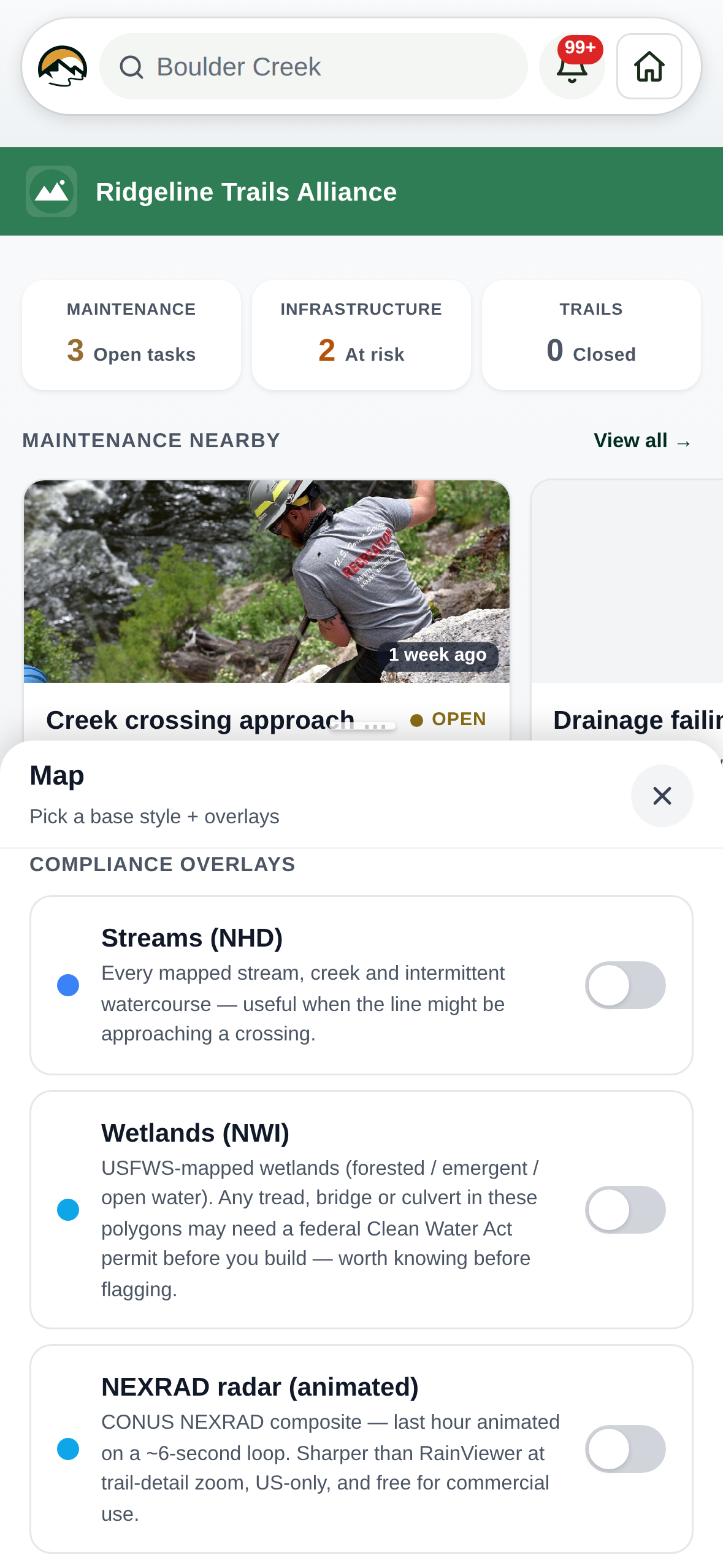
What each layer answers
The first four draw from United States federal mapping services, so
they are offered to organizations in the US and are not shown
elsewhere. A row that could be switched on and paint nothing would
read as a broken map rather than as ground the data does not cover.
Set your country in Settings → Organization details — that is what
the map checks.
Streams (USGS NHD) — every mapped watercourse, including the intermittent ones that are dry when you walk them and are still a crossing on paper.
Wetlands (USFWS NWI) — federally mapped wetlands. Tread, bridge or culvert inside one of these polygons may need a Clean Water Act permit before you build, which is worth knowing at flagging time rather than at inspection time.
Public lands (BLM) — federal, state and tribal ownership: BLM, Forest Service, Park Service, Fish and Wildlife, Defense, state and tribal. This is the layer that tells you which agency to talk to.
NEXRAD radar — the last hour of precipitation, animated. It also turns itself on when you open the rain tab in the weather panel, and the chart's scrubber drags the radar with it.
Business names — the names of shops, fuel stations, food and other named places, drawn from zoom 13 in. It is off by default because on a trail map most of the time they are clutter; it is there for the times you are looking for the nearest gas station, hardware store or somewhere to eat before the drive home. Alongside the businesses it labels a few things that are not one — a town hall, a library, a church — because it works by drawing every named place no other layer has already labeled, which keeps a new kind of shop appearing on its own rather than waiting for us to add it to a list.
These names come out of the same map data the base map is already drawn from, so they work in a download with no signal and they cost nothing extra to store. They appear on the TrailsIQ map. On an organization using a commercial base map the switch is not offered, because that map draws its own business labels and a switch that could not turn them off would be worse than none.
Property lines
Two layers, and they answer different questions.
Property lines are parcel boundaries with the owner of record, where a state publishes them: Vermont, Massachusetts, New York, Wisconsin and Florida today. Each comes from that state's own agency — VCGI, MassGIS, NYS ITS, the Wisconsin Land Information Program, and Florida's GIO — so zooming in past the boundary gives you a name.
Some parcels have no name against them: the assessment row is missing, or it is not a taxed property. It is about one in twenty in Vermont, closer to one in a hundred in Massachusetts and New York. Those still draw their lines, and the town or county assessor is where an unnamed one gets settled.
Florida counts differently, and it is not a fault. Its cadastral is one record per tax roll entry, so a condominium building is a stack of parcels sharing one footprint and a downtown block can return several hundred overlapping lines.
Section lines are the Public Land Survey System grid: townships, ranges and sections. Not ownership, but it is the frame deeds are written against across most of the country, and it is available everywhere.
Property lines are not a survey, and the difference matters. They are assessor mapping — drawn to administer taxes, not to settle boundaries — and being off by several meters is normal. The error is usually worst where old deeds meet, which is exactly where somebody wants to know. Treat the layer as "the line is somewhere near here, go and ask", and confirm with the town or a surveyor before building close to one.
Why the toggle is sometimes not there
Parcels are county records. There is no national parcel map, free or paid, that any one authority maintains — about three thousand counties each keep their own, and some states aggregate them while most do not.
So the property-lines toggle appears only where we have a source for the ground you are looking at, and it follows the map rather than your organization: pan across a state line and it can appear or disappear. That is coverage changing, not a fault.
One state at a time. Coverage is matched against a rectangle around each state, and rectangles overlap — the one around New York contains the whole of Vermont. Only the closest-fitting state is offered, so you never get a second row that could only ever say no parcels mapped here. Along a border that is a river rather than a straight line, the map can still offer the wrong side's layer for a few miles; it draws nothing there and says so.
We would rather show nothing than a switch that paints nothing. If your state publishes parcels and you do not see the toggle, ask us — adding a state is a small change at our end.
Two things to expect
Property lines load when you zoom in. Past about zoom 14 — a few blocks across the screen. Further out, the number of parcels in view is in the tens of thousands and the state's service will not answer for them, so the layer stays empty on purpose rather than half-loading.
These layers need a connection. They stream from the agency that publishes them and are not part of an offline download, so on a phone with no signal the toggles are hidden rather than shown painting nothing. Downloaded trails, tasks, photos and the base map all still work offline as usual.